


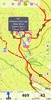
Explore the outdoors confidently with German Topo Maps, featuring a comprehensive collection of topographic maps and satellite images tailored for outdoor enthusiasts. This GPS navigation application is perfect for anyone looking to venture beyond the reach of cell coverage. Whether you're hiking, biking, or engaging in any backcountry exploration, use it to view your current position on various maps, track your path, and share your location with others.
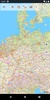
The application boasts over 50 map layers specifically for Germany, complemented by 10 worldwide coverage layers. Top-tier sources provide high-resolution aerial imagery, detailed topographical maps, digital terrain models, and even cadastral maps across numerous German states. From unearthing hidden trails and streams to identifying specific contour lines, these maps present the pinnacle of accuracy and detail.
Global users aren't left out, with OpenStreetMap layers available, revealing a wealth of unique features. For cycling enthusiasts, OpenCycleMaps (exclusively for PRO users) are the ideal tool to plan your next biking adventure. A variety of overlays such as hillshading augment your navigation experience, enriching the presentation with valuable terrain information.
Key features include Waypoint creation and editing, Tripmaster tools providing essential travel data, and the ability to export your adventures in various formats. Map View and Tripmaster are customizable, allowing selection from a range of data fields like speed or distance.
For a seamless off-the-grid experience, the app's offline functionality eliminates the need for a cell signal and roaming fees, with the option for easy, fast bulk downloads of map tiles for offline use. With the PRO version, not only are advertisements bypassed, but also enhanced capabilities such as Route-Navigation and additional map sources are available.
This tool is a companion for all outdoor activities, from trekking in remote areas to weekend offroading. Add waypoints with precision using multiple coordinate systems, and even import and export routes and tracks to plan and share your journeys. For areas without cell reception, preloading map data ensures you're always prepared—just one of the key features unlocked with the Pro version.
With an established commitment to user privacy, German Topo Maps ensures that user activities and data remain strictly confidential. Prepare for your next outdoor adventure and explore with confidence, knowing you have the very best in GPS navigation at your fingertips.
Requirements (Latest version)
- Android 7.0 or higher required
Comments
There are no opinions about German Topo Maps yet. Be the first! Comment